| |
About the JIRP Survey Reports
All the reports presented here are based on research conducted on
the Juneau Icefield, Alaska between 1988 and the present. All work was conducted under the
financial and logistical support of the Juneau Icefield Research Program and its parent
organization, the Foundation for Glacier and Environmental Research. Additional support
was provided by the National Science Foundation, National Geographic Society, NASA, the
Army Research Office, University of Idaho Glaciological and Arctic Sciences Institute,
University of Alaska Southeast, the Juneau Rotary Club, and private donors.
All survey work described in these reports was conducted and
supervised by
the following individuals:
-
Scott McGee,
Foundation for Glacier and Environmental Research, Moscow, Idaho
and Anchorage, Alaska
- Dr.-Ing.
Walter M. Welsch, Universität der Bundeswehr München, Munich, Germany
- Dipl.-Ing.
Martin Lang, Universität der Bundeswehr München, Munich, Germany
- Susann Beuttner, Universität der Bundeswehr München,
Munich, Germany
- Ronny Wenzel, Universität der Bundeswehr München,
Munich, Germany
- Dr. Werner Stempfhuber, Swiss Federal
Institute of Technology, Zurich, Switzerland
- Claudia Roosli, Swiss Federal Institute
of Technology, Zurich, Switzerland
- Florence Vaudan, Swiss Federal
Institute of Technology, Zurich, Switzerland
- Melanie Kunz, Swiss Federal Institute
of Technology, Zurich, Switzerland
Student participants involved in the survey
field work were supported by the Young Scholars Program and the Research Experience for
Undergraduates programs of the National Science Foundation, by NASA, and by the Army
Research Office.
|
|
A
The purpose of the surveying program is to
collect annual data
relating to the surface movement, elevation, and strain rates of baseline profiles across
the Juneau Icefield. Additionally, new survey profiles are established annually in order
to extend investigations into unsurveyed areas. Terrestrial-based surveys of several of
the baseline profiles have been conducted over the course of several decades. More
recently, GPS-based survey methods have been adopted and have replaced the older method.
Unfortunately, strict comparisons of movement and elevation data obtained with high
precision GPS equipment and techniques and those data obtained in the past with lower
precision theodolite/EDM methods cannot be made. This is due to the fact that, before the
advent of real-time GPS, it was nearly impossible to place the survey stakes in the same
exact positions from year to year.
Most of the reports presented here detail survey work carried out
with rapid static and real-time GPS equipment and techniques, giving an accuracy of
approximately 1 cm horizontally and 5 cm vertically. Some of the earlier reports are based
on traditional terrestrial survey techniques which utilized theodolites and EDMs. These
older reports are presented here for the sake of historical documentation of the survey
activities on the Juneau Icefield. Researchers and casual readers are cautioned that
direct, quantitative comparisons cannot be made between the data in the
GPS reports and the older theodolite/EDM reports.
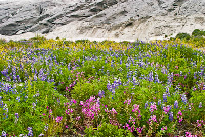
Fireweed and lupine in bloom at
the terminus of the advancing Taku Glacier, which will soon
obliterate this lush patch of wildflowers
|
|