|
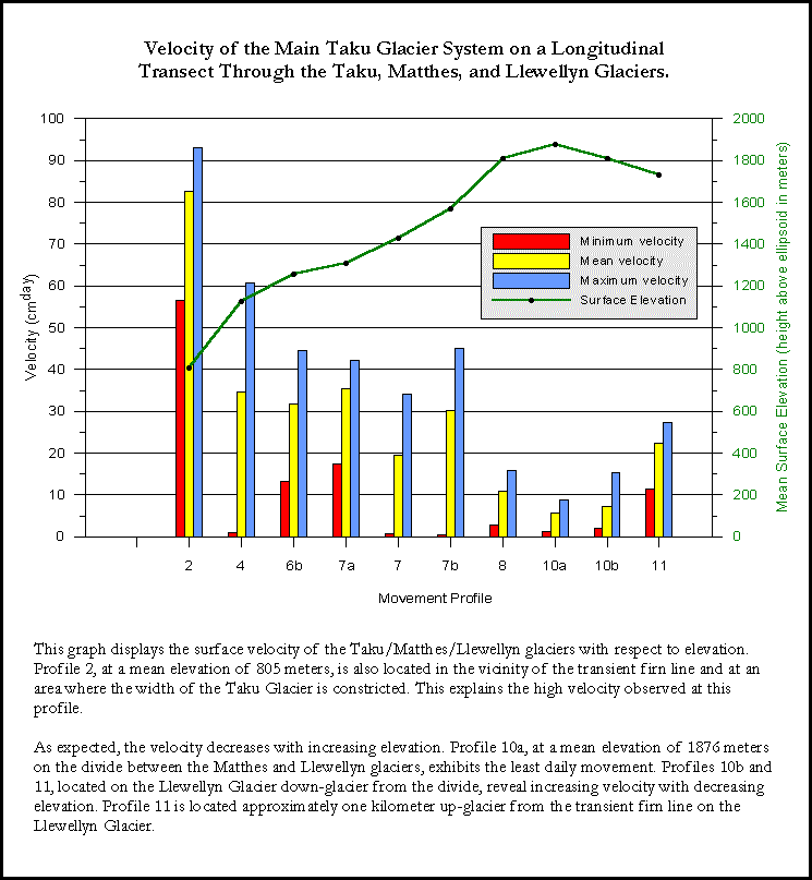
The above graph shows the surface
velocity of the Taku / Matthes / Llewellyn glacier system as a function
of elevation and distance from Taku Point. This point is on the
south side of Taku Inlet and is approximately 1.3 kilometers
south of the Taku Glacier terminus.
JIRP has established a series of
longitudinal survey profiles throughout the entire Taku Glacier
system. The data shown above was collected along Longitudinal A,
which begins at Taku Point and continues up the main Taku and
Matthes glaciers. It then crosses over the Continental Divide
and down the Llewellyn Glacier. Points are surveyed every 500
meters along this longitudinal transect. The magnitude of
velocity is indicated by the size of the circles. The white line
within the circles shows the surface elevation of the glacier.
The effect of valley width and
depth on velocity is not considered here. Generally
speaking, glacier velocity increases with increasing distance
from the glacial divide. Local geomorphic characteristics also
have an effect on velocity. For example, 50 kilometers upglacier from the Taku
terminus, the valley steepens
|
and
narrows, resulting in the local velocity increase in this area.
With the exception of one
transverse survey profile five kilometers upglacier from the
Taku Glacier terminus and several scattered velocity
measurements at the terminus, we have no velocity data for the
lower Taku Glacier from the terminus to approximately 14
kilometers upglacier. This is indicated by the
data gap in the graph from 0 to 14 kilometers. However, we know from our
velocity data at the terminus that the velocity slows relative
to the first point surveyed on Longitudinal A (indicated by a
velocity of 114 cm/day). Thus, the Taku / Matthes system
exhibits a common velocity pattern of increasing velocity from
the source to the firn line, and then decreasing velocity from
the firn line to the terminus. In the case of the Taku Glacier,
the velocity decrease near the terminus is an effect of the
radially expanding piedmont lobe at the terminus.
|