| |
.jpg)
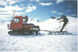
This is how it was done in the old days (1988). It used to be that we could survey only when the weather was nice (tough life, eh?). But now with GPS, we're able to survey when it's raining, blowing,
snowing, and cold (isn't technology supposed to
make things easier?).
.jpg)
A typical movement profile is composed of a line of
stakes placed from one side of a glacier to the other.
This profile is on the Northwest Branch of the Taku
Glacier. The flags, made of garbage bags stapled to
1" x 2" wooden stakes, are placed, in this photo, at
an interval of 317 meters. The average daily movement
of the glacier at this profile is 6 cm.
.jpg)
Benchmarks are extremely important in glacier surveying.
They serve as a known reference point for determining how
an unknown point on the glacier is moving. These benchmarks
are cemented in holes that are drilled into solid bedrock.
.jpg)
And this is how the holes are drilled. A special steel rock
drill is literally hammered into the rock, creating a 3/4"
diameter hole. The brass benchmark is then cemented
into the hole. In hard granodiorite, it takes about 3-4
hours to drill a hole 2" deep. It helps to have several
people who can take turns hammering!
.jpg)
After the benchmark is cemented in place it must be
surveyed to determine its exact position. To do this,
a GPS receiver is centered over the benchmark. Satellite
signals are then collected for several hours. The data,
when combined with the data from a GPS receiver
positioned over a known benchmark, then gives the
position of the new benchmark within the
International Terrestrial Reference Frame.
.jpg)
In order to determine glacier movement to within a few centimeters, a GPS receiver must be set up at a benchmark. This base station then serves as a reference in determining the position of a second receiver that is placed at each of the flags of a movement profile. This photo shows the base station set up over a benchmark on a nunatak.
The Taku Glacier is in the background.
.jpg)
After setting up the reference receiver, the survey can
commence. In the photo above, we've just placed the
reference receiver and are heading down from the
nunatak to begin the survey.
.jpg)
While the reference receiver is operating back at the
benchmark, the roving receiver is placed at each flag
of the movement profile. This photo shows the rover
set up and collecting data at one of the flags, which has
been removed, and the GPS antenna put in its place.
.jpg)
Here's a closer view of the roving receiver in operation.
.jpg)
The reference and roving receivers collect signals from
multiple GPS satellites. Here, the roving receiver is
currently tracking and receiving the signals from
five different satellites.
.jpg)
You've heard the saying, "Hurry up and wait." Well, that
definitely applies to GPS surveying when
doing a rapid-static survey as we're doing here. The
receiver is placed at each flag for 15 minutes, during
which time it takes a reading every 15 seconds. Then,
we hurry to the next flag so that we can wait again.
.jpg)
Here's another example of "hurry up and wait." Before the use
of GPS equipment, surveying was accomplished with theodolites
and EDMs. This required clear visibility from the benchmark to the
flags in order to perform a survey. While fog often limited visibility,
it was common to head out in a total whiteout in the hope that the
fog would clear by the time we arrived at the survey site. More often
than not though, we would simply end up waiting on a nunatak all day
for the weather to clear, only to return to camp with no survey data.
Here, you see our makeshift rain shelter where we're waiting for
the weather to clear enough to do the survey. |
|
.jpg)
Here's another view of our rain shelter later in the day
bathed in a small patch of sunshine. Although the weather
was starting to look promising, it soon closed in again.
Result: no surveying this day!
.jpg)
While we can use oversnow vehicles
for much of the
survey work, some areas require leaving the vehicle
behind and proceeding on foot. This is particularly
true near the edges of the glaciers, where often
extensive marginal crevasse zones require close
scrutiny for safe travel.
.jpg)
And in some areas, such as in the Gilkey Trench shown
here, vehicle support cannot be used at all. In such cases,
everything we need, including survey stakes, has to be
carried down on our backs. This photo was taken in 1990.
During the summer of 1998, the lower third of the
icefall in the background broke loose, exposing the
bedrock underneath it. By the summer of 2000, the
icefall was
completely
detached from the Gilkey Glacier.
.jpg)
Here, a GPS survey is being conducted at the base
of the Vaughan Lewis Icefall to determine surface
velocities, elevations, and strain rates. The movement
here was measured at 39 cm/day.
.jpg)
Most surveys on the Juneau Icefield are done to
determine surface movement and elevation changes.
Periodically, we also survey the terminus of the advancing
Taku Glacier to determine its rate of advance. Here,
across the Taku River from the glacier, a helicopter
ferries people and equipment to a reference point.
.jpg)
Before GPS totally replaced traditional surveying
methods, theodolites and EDMs were the tools of
choice. Here, a member of the survey team sets up
the equipment in preparation for surveying the
terminus of the Taku Glacier, which is seen in
the background.
.jpg)
While most glacier surveying involves the use of a
stationary benchmark on a nunatak, sometimes the
requirements of a survey project dictate setting up
directly on the glacier surface. One such survey is
shown above. The objective here was to determine
the strain rate across a triangular area of the glacier.
This allows us to calculate how one part of the glacier
is moving in relation to other parts.
.jpg)
While one team member takes angle and distance
observations from one point of the strain triangle,
another person sets up the target at one of the other
points of the triangle. Prisms mounted on the tripod
reflect the infrared beam from the EDM back to the
observation point, thereby giving the distance between
the observing and target points.
.jpg)
When doing theodolite surveys, it was imperative that
we take advantage of every clear day. On this particular
cloudless day, surveying was going full bore. The
theodolite on the right was employed for surface
movement surveys of the Gilkey Glacier, while at the
same time the phototheodolite on the left was
being used for a photogrammetric survey of the
Vaughan Lewis Icefall in the background. The
umbrella was used to shade the instruments from
the distorting effects of solar radiation.
Unlike the days when we used to perform surveys on
skis, we now rely on the rapid transportation available
by oversnow vehicles. When establishing the survey
flags for the first survey of the summer, the driver
uses a handheld GPS to navigate to within 3 meters
of the spot where the flag is to be located. The person
riding in the sled then uses high precision real-time
differential GPS to find the exact spot to within 10-50
centimeters. The survey flag is then placed and surveyed.
.jpg)
Most movement profiles on the Juneau Icefield are
transverse profiles; they extend from one side of a
glacier to the other. This provides data on the cross-glacier movement profile, but it does not show how
the movement of the glacier varies along its longitudinal
centerline. This photo shows the survey of a longitudinal
profile on the Taku/Matthes/Llewellyn Glaciers. This
profile follows the centerline of the glaciers, with survey
points spaced at 500 meter intervals. This gives a very
detailed view of the spatial variation of surface
velocity, elevation, and gradient.
|
|
.jpg)
.jpg)
.jpg)
.jpg)
.jpg)
.jpg)
.jpg)
.jpg)
.jpg)
.jpg)
.jpg)
.jpg)
.jpg)
.jpg)
.jpg)
.jpg)
.jpg)
.jpg)
.jpg)
.jpg)
.jpg)
.jpg)
.jpg)